Recent News
- Waves Group Celebrate 5 Years of Operation in Singapore
- Major Milestone Achieved in the Decommissioning of the Historic Royal Sovereign Lighthouse
- Waves Group Welcomes Captain Stanislav Ivanov as Vice President of the Houston office
- Waves Group Goes Green with Green Marine’s Project Verdant – UK’s First CTV (Crew Transfer Vessel) Powered by Hydrogen
- A New Organisational Structure for Waves Group Board of Directors
Archives
- March 2024
- December 2023
- November 2023
- June 2023
- April 2023
- February 2023
- January 2023
- November 2022
- October 2022
- September 2022
- August 2022
- July 2022
- June 2022
- May 2022
- April 2022
- March 2022
- February 2022
- September 2021
- June 2021
- May 2021
- March 2021
- February 2021
- January 2021
- December 2020
- October 2020
- September 2020
- August 2020
- July 2020
- April 2020
- March 2020
- February 2020
- January 2020
- December 2019
- November 2019
- October 2019
- September 2019
- August 2019
- June 2019
- May 2019
- April 2019
- March 2019
- February 2019
- January 2019
- November 2018
- October 2018
- September 2018
- July 2018
- May 2018
- September 2017
- July 2017
- January 2017
- December 2016
Waves Group’s High-Resolution 3D Data Acquisition Capability used in Legacy Wreck Risk Assessment
December 19, 2019
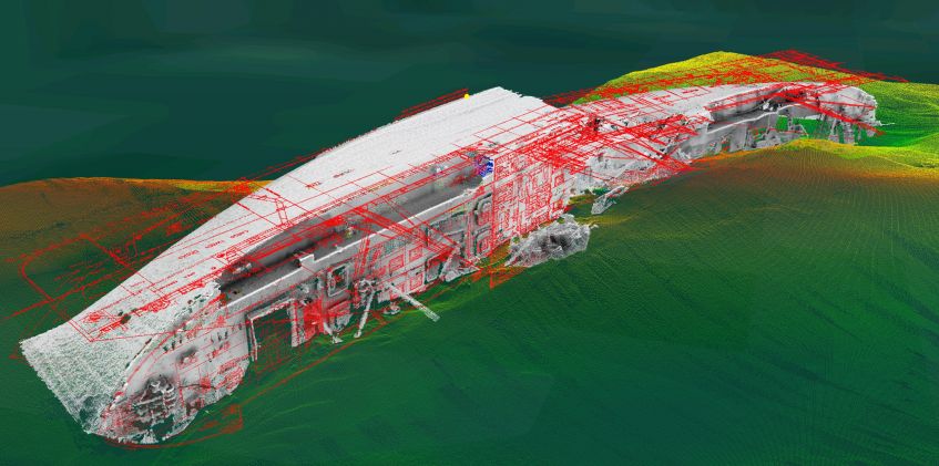
Over the summer Waves Group were engaged to undertake a detailed assessment of one of the UK’s Second World War legacy wrecks. This largely intact wreck presented a pollution risk as she was a freighting tanker carrying significant quantities of heavy oil in seven cargo tanks when she sank. The wreck lies some distance offshore in deep water, with low visibility and strong currents making conditions challenging on site.
Our recently developed 3D subsea data acquisition and visualisation capabilities were brought to bear on the project, which when combined with the extensive marine engineering and naval architecture experience already in house, meant we were able to more effectively inform and input into the client’s intervention strategy for this potentially polluting wreck. As a result, our client’s situational awareness was vastly increased and fear of the unexpected reduced, which meant that more informed decisions could be made, and more decisive action taken.
At the start of a project like this, the amount and quality of data is limited, but the benefit of decisions made is high, rapidly falling away with time. We therefore quickly conducted a high-resolution 3D survey of the wreck using a work class ROV spread from a DP vessel, and then processed the data onboard in order to devise a precise sampling strategy for the assessment of remaining hydrocarbons. The incorporation of existing GA plans for the vessel within the fully georeferenced 3D survey data allowed the precise location of the seven cargo tanks to be quickly determined, so that the ROV’s neutron backscatter device could undertake the sampling regime accurately and without delay.
The digital deliverables supplied to the client were in an interactive 3D format that allowed effective communication and collaboration amongst all the stakeholders – even for non-specialists. It is often the case that means of communicating and exchanging information about complex objects in challenging environments, such as wrecks on the seabed, are still delivered in 2D form – printed reports and 2D diagrams and images. However, as most humans are visual thinkers it is only by embracing 3D technology that we can convey greater understanding by bridging the gap between the physical world and our own internal vision.
The results were presented using 3D GIS allowing the client to ‘fly around’ the data and undertake their own basic analysis, providing a clear understanding of a complex situation. Additional data from previous survey work was also included to provide 4D information to evaluate change over time. The data could also be viewed at 1:1 scale in Virtual Reality.
Waves Group’s digital technology suite of services provides certainty and increased situational awareness, and informed the onsite decision making and intervention strategies to levels not previously possible.
For further information about our 3D high-resolution digital capabilities please contact mail@waves-group.co.uk.