Recent News
- Waves Group Celebrate 5 Years of Operation in Singapore
- Major Milestone Achieved in the Decommissioning of the Historic Royal Sovereign Lighthouse
- Waves Group Welcomes Captain Stanislav Ivanov as Vice President of the Houston office
- Waves Group Goes Green with Green Marine’s Project Verdant – UK’s First CTV (Crew Transfer Vessel) Powered by Hydrogen
- A New Organisational Structure for Waves Group Board of Directors
Archives
- March 2024
- December 2023
- November 2023
- June 2023
- April 2023
- February 2023
- January 2023
- November 2022
- October 2022
- September 2022
- August 2022
- July 2022
- June 2022
- May 2022
- April 2022
- March 2022
- February 2022
- September 2021
- June 2021
- May 2021
- March 2021
- February 2021
- January 2021
- December 2020
- October 2020
- September 2020
- August 2020
- July 2020
- April 2020
- March 2020
- February 2020
- January 2020
- December 2019
- November 2019
- October 2019
- September 2019
- August 2019
- June 2019
- May 2019
- April 2019
- March 2019
- February 2019
- January 2019
- November 2018
- October 2018
- September 2018
- July 2018
- May 2018
- September 2017
- July 2017
- January 2017
- December 2016
Waves Group Pollution Mapping – “It’s Not What Happens to You, But How You React to It That Matters” Epicetus (Greek Philosopher)
August 3, 2020
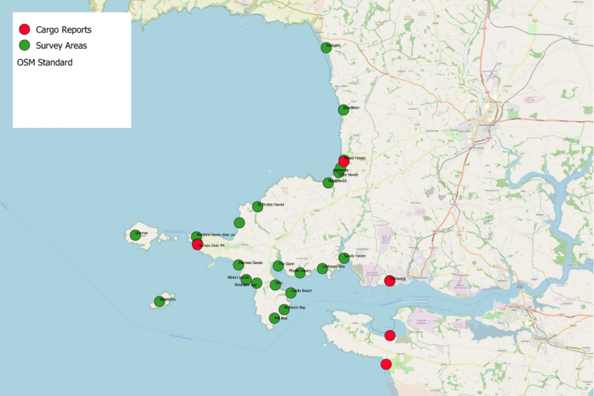
Live mapping of pollution reports to coordinate and manage response operations to reduce the impact of the pollution and mitigate the costs of the operation.
Waves Group has been assisting clients with a number of cargo loss and pollution cases, advising on the recovery and clean-up operations, costs and managing the operation on behalf of P&I Clubs and their Members.
As well as the practical, on-the-ground response and incident management, we have utilised our digital capabilities to provide efficient and regular situation reports on the operations, current status and necessary actions. Using Geographical Information System (GIS) tools that enable sightings of cargo or pollution to be uploaded and combined in a single map-based view it provides an overview of an incident and the current operational status.
Reports can be made by everyone from public volunteers through to incident responders, and can provide a real-time update on sightings (reported and confirmed) and status. Each report can be interrogated to provide further information to aid the planning of the response.
These tools have proven to be very beneficial when providing stakeholders with regular updates, including national authorities, responders and those ultimately paying for the operation, in this case the vessel’s P&I Club. Operationally, it is of great assistance when managing clean-up contractors to ensure the appropriate resources are being used where they are needed most. This applies to both the immediate clean-up at site and, the transfer, storage and disposal of waste streams arising from the incident, which can be a hidden cost.
In one particular example, involving the loss of a number of containers overboard, the majority of plastics in the cargo that subsequently washed ashore were recycled through proactive planning and response with the local authorities, clean-up contractors and disposal facilities.
These cases have demonstrated the benefits of marrying many years of training and practical experience with advanced technology to enhance incident response operations and to minimise both the financial and environmental impact of an incident.
These tools also enable the prediction of material coming ashore, for example after storm events, thereby ensuring efficient deployment of clean up resources before material could spread further. Furthermore, such predictions can be used to evaluate search and potential trajectory patterns.
By providing on-line, real-time tools for incident management, collaboration and communication between stakeholders are improved and key decisions can be made quickly and effectively, enabled by the sharing of up-to-date, critical incident information.
If you would like to learn more, please contact us.