Recent Posts
Everyday tech: the power in your pocket
Blog Post by: Mark Lawrence
March 14, 2022
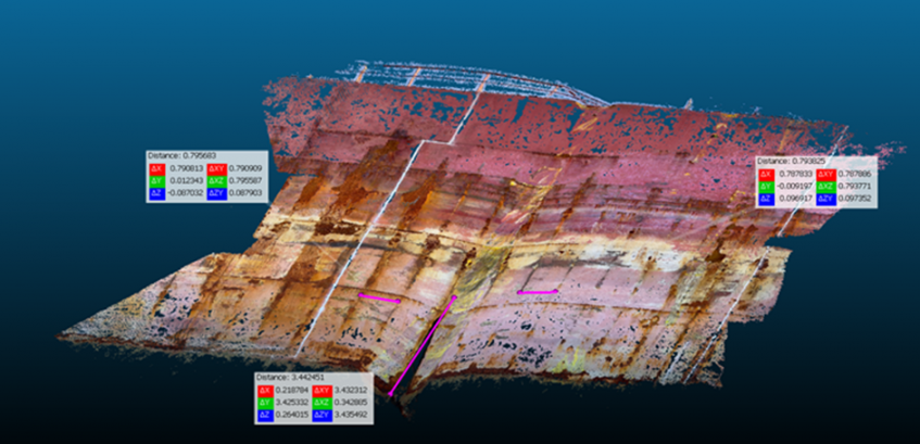
Scaled 3D point cloud of damaged area with some measurements
Here at Waves Group, our consultants often find themselves in challenging situations, charged with gathering information as part of maritime incident investigation cases around the world, and in the first instance are relying on their natural senses to make assessments and quantify damage quickly, coupled of course, with experience & expertise.
However, these days, as well as a trusty notebook and pen, the next thing to pull out of their pockets is usually a smart phone. Most of us are carrying them of course, but many might not realise the capability they can offer. For us, the most immediate use in this scenario will be to take photos and video at high resolution, with 4k footage at high frame rates a common feature of many phones these days, and perhaps also to share such imagery with the office and other colleagues.
However, we are making much more possible. On a recent case, one of our consultants attended a vessel to conduct a damage survey at very short notice. It was important to get a good understanding of the extent of the damage, but in the first instance access to the damaged area of the vessel externally was restricted to viewing from the quayside.
With just a short amount of high-resolution video shots from a phone, we were able to quickly create a 3D model of the damaged area using photogrammetrical techniques, that allowed a far better initial assessment of the damage than was possible otherwise. Whilst such a 3D model generated in this way isn’t comparable in terms of accuracy or precision with, say, a full laser scanning technique, it nevertheless provided detail over and above that which could have been achieved otherwise and with minimal extra effort. The point here is that often we are trying to make best use of limited time and available resources in challenging environments to achieve good situational awareness, and the creation of a measurable 3D model from a short phone video is a good illustration of how we can achieve that.
From the video data, an initial 3D point cloud of the damaged area was created and then used to determine the extent of the indentation in the side shell plating. An assessment of the indentation in this case was important to understand the likely forces involved in the impact and therefore make further assessments on the residual capacity of the object that the vessel had collided with in the incident.
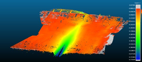
Point cloud coloured to represent distances from reference point
Using colours to show the grading of the measurements enables a clear visual representation of the extent of the damage and allows much better assessment of the depth and nature of the indentation.
In this case, we were making use of just the video acquired using just the phone, with no additional equipment or mobilisation and this allowed us to take measurements that could not be done physically, at such short notice. Such a case goes to show the enormous power that we carry in our pockets these days.
Oh, and we haven’t even mentioned some of the other tools that the average smart phone contains that we are using in investigating incidents………